BBC Tyne Regional Latest

Berwick upon Tweed


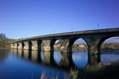
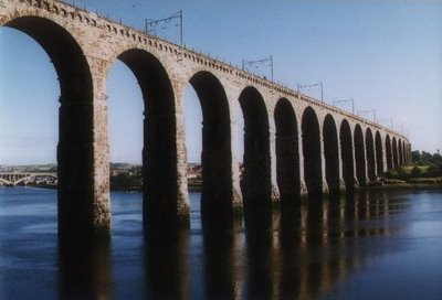
The Royal Border Bridge across the River Tweed.


Berwick Barracks - home of the Kings Own Scottish Borderers.

Berwick-upon-Tweed (commonly called just Berwick) is the most northerly town in the county of Northumberland and in England. The town has a population of about 12000 and is the administrative capital of Berwick Borough.

Berwick has changed hands several times throughout history. For a period of 300 and more years from the mid 11th century the town was an extremely important strategic asset in the wars between England and Scotland. The architecture of the town reflects its past, in particular in having one of the finest remaining defensive ramparts (of 1555, though much repaired in the late 18th century), and in the Barracks buildings, begun in 1717 and the first such buildings in Britain. Nikolaus Pevsner writes that Berwick is one of the most exciting towns in the country, with scarcely an irritating building anywhere, and the most intricate changes of level.

Today the Barracks is maintained by English Heritage and is the regimental home of the Kings Own Scottish Borderers. The town is also the lowest bridging point of the River Tweed, an important salmon fishery on the England-Scotland border.

The Old Bridge, a 15-span sandstone arch bridge measuring 1,164 feet in length, was built between 1610 and 1624. The bridge continues to serve road traffic, in one direction only. The current structure is a Grade I listed. Four previous bridges stood on the site, with two destroyed by flooding (in 1199, the original, and in 1294, the third), one by an English attack in 1216 and the last, built 1376, served until James I of England ordered the construction of the present bridge. It was then on the main road from Edinburgh to London, and the king (who was also James VI of Scotland) had had to cross over the then dilapadated wooden bridge in 1603 while travelling to London for his coronation.

The Royal Border Bridge, designed and built under the supervision of Robert Stephenson between 1847 at a cost of £253,000, is a 720-yard-long railway viaduct with 28 arches, carrying the East Coast Main Line 126 feet above the River Tweed. It was opened by Queen Victoria in 1850.

The Royal Tweed Bridge, built in 1925 and in its time having the longest concrete span in the country at 361 feet, was originally designed to carry the A1 road across the Tweed; the town now has a road bypass to the west. In the early 2000s, its fabric was renovated, the road and pavement layout amended, and new street lighting was added. Construction work was undertaken by L G Mouchel & Partners, who still operate today (as Mouchel Parkman). The design is of reinforced concrete and consists of four unequal arches.

The Union Bridge (five miles upstream), the world's oldest surviving suspension bridge. When it opened in 1820 it was the longest wrought iron suspension bridge in the world with a span of 137 metres (449 ft), and the first vehicular bridge of its type in Britain. Although work started on the Menai Suspension Bridge first, Union Bridge was completed earlier. Today it is the oldest suspension bridge still carrying road traffic.

Another quirky part of town's history is the Berwick Parish Church, unique for having been built during the Commonwealth of Oliver Cromwell. The building, constructed around 1650 using stone from the 13th century Castle (parts of which still stand by the railway station), began as a plain preaching box, with no steeple, stained glass or other decorations. Much altered with a conventional interior layout, contents include a pulpit thought to have been built for John Knox during his stay the town.

It is unique for an English town in that its football team, Berwick Rangers, plays its matches in the Scottish Football League; owing to the south-west to north-east direction of the border, it is located further north than several Scottish league clubs including Gretna, Queen of the South (Dumfries), Stranraer, Ayr United and Kilmarnock.

If you are interested in history, architecture and like the fresh sea breeze Berwick is an ideal place to visit.

Article adapted from the Wikipedia online encyclopedia.

How to get to Berwick:
By road: Berwick is conveniently located just off the main A1 road. It is about 60 miles north of Newcastle upon Tyne and 90 miles south of Edinburgh.
By rail: The nearest station is Berwick upon Tweed. The station is on the main east coast railway line and is served frequently by trains from London and Newcastle upon Tyne in the south and Edinburgh in the north.
By bus: Arriva Northumbria services 501 and 505 (525 on Sundays and Bank Holidays) runs from Newcastle upon Tyne via Morpeth, Alnwick, the North-Northumberland coast up to Berwick. Travelsure service 23 links Kelso in the Scottish Borders and Berwick. Perrymans service 253 links Edinburgh and Berwick.

Map of area: CLICK HERE
Prudhoe


Prudhoe Castle stands guard over the River Tyne.

Prudhoe is a small town in the southern part of the English county of Northumberland in the district of Tynedale, close to the border with Tyne and Wear and just south of the River Tyne. Prudhoe is officially the largest town in Tynedale with a population of over 11,500. Perched on the steep southern slopes of the Tyne Valley, Prudhoe has for centuries had a strategic role. Prudhoe Castle was erected in the 12th century and overs the river, the town has grown in importance around it. Today, industry plays a major part in Prudhoe's economy. Prudhoe has two large factories - SCA Hygiene (formerly Kimberly-Clark) which makes paper products such as tissues at their Prudhoe Mill factory, and Hammerite Products, an ICI owned factory producing paints for Cuprinol, Hammerite and various brands as well as thinning products. Waterworld, a leisure pool, provides a relaxing which brings a relaxing tropical feel for the townsfolk. The Tyne Riverside Country Park follows the river's edge and a former railway line across a bridge which might be familiar to residents of Sydney and Newcastle.

The gatehouse, curtain wall and keep are all that remain of the castle, which is owned and maintained by English Heritage.

Article adapted from the Wikipedia online encyclopedia.

How to get to Prudhoe:
By road: Prudhoe is conveniently located just off the main A69 road, about 10 miles west of Newcastle upon Tyne.
By rail: The nearest station is Prudhoe. Connecting rail services are available from Carlisle in the west and Newcastle upon Tyne in the east.
By bus: The Carlisle-Newcastle service, route 685, operates via Prudhoe on weekdays. On Sundays service 85 operates hourly from Newcastle Eldon Square to Prudhoe. Services X85 and 185 also operate between Newcastle and Prudhoe but these services are very infrequent. Check bus times before travelling.

Map of area: CLICK HERE
Hexham


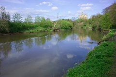
River Tyne at Hexham.


Hexham abbey.

Hexham is a large market town in Northumberland, England, located south of the River Tyne. Hexham is the administrative centre for the Tynedale district, although in terms of population, Prudhoe is now Tynedale's largest town. In 2001, it had a population of 11,139.

There are many smaller towns and villages that surround Hexham, such as Corbridge, Riding Mill, Stocksfield, Wylam to the east with Haydon Bridge and Bardon Mill to the west. The closest major city to Hexham is Newcastle upon Tyne and is approximately 25 miles (40 km) to the east.

Hexham originated as a monastery founded by Saint Wilfrid in 674. The crypt of the original monastery survives, and incorporates many stones taken from nearby Roman ruins - probably Corstopitum or Hadrian's Wall. The current Hexham Abbey dates largely from the 11th century onward, but was significantly rebuilt in the 19th century. Other notable buildings in the town include the Moot Hall, the covered market, and the Old Gaol.

The name of Hexham came from Anglo-Saxon Hagustaldeshām = "Hagustald's home" or "the hedge-warden's home", although it is often incorrectly regarded to mean "land or settlement of witches".

Like many towns in the North of England, Hexham suffered from the border wars with the Scots, including attacks from William Wallace who burnt the town in 1297. In 1312, Robert the Bruce, King of Scotland, demanded and received £2000 from the town and monastey in order to be spared a similar fate.

In 1715 the 3rd Earl of Derwentwater raised the standard for the Old Pretender in Hexham Market place, however the rebellion was unsuccessful, and the Earl was captured and beheaded after the battle of Preston.

Hexham was the county town of the former county of Hexhamshire.

Article adapted from the Wikipedia online encyclopedia.

How to get to Hexham:
By road: Hexham is conveniently located just off the main A69 road, about 20 miles west of Newcastle upon Tyne.
By rail: The nearest station is Hexham. Connecting rail services are available from Carlisle in the west and Newcastle upon Tyne in the east.
By bus: The Carlisle-Newcastle service, route 685, operates via Hexham on weekdays. On Sundays service 85 operates hourly from Newcastle Eldon Square to Hexham. Services X85 and 185 also operate between Newcastle and Hexham but these services are very infrequent. Check bus times before travelling.

Map of area: CLICK HERE
Rothbury and Simonside


Climbers enjoy Simonside crag, overlooking sleepy Rothbury below.

Nestled snuggly between the Simonside Hills on the edge of the Northumberland National Park, you'll find the small market town of Rothbury. On the approach to the town you'll find the National Trust's Cragside house and gardens.

Cragside house is set in over 1000 acres of pine-covered hillsides, lakes and tumbling streams. The house, boasting hot and cold running water, central heating, a passenger lift and Turkish bath was a huge feat of civil engineering when it was built back in the 1880's. The house was also the first place in the world to be lit by hydroelectricity.Visitors can go and explore the pumping houses, turbine rooms, hear the grating metal and smell the burning of oil exactly the way it was 130 years ago. The estate has an extensive network of tracks, lakes, streams, ornamental gardens and a visitor centre.

To the south of the town lie the imposing Simonside hills. The hills are a designated special area of conservation and comprise rolling moorland, grassland and conifer woodland. The Forestry Commission maintain much of the land, which is open for walking, mountain biking, horse riding, picnics and general recreation. There are spectacular views up the Coquet Valley to Thropton and further afield.

Article adapted from the Wikipedia online encyclopedia and Rothbury Village website.

How to get to Rothbury:
By road from the south: take the main A1 trunk road from Newcastle upon Tyne. Turn off at Alnwick, which is about 35 miles north of Newcastle on the left and is clearly sign posted. Head for Alnwick town centre and then take the B6341 road to Rothbury.
By road from the north: Take the main A1 trunk road from Edinburgh and Berwick upon Tweed. Turn off at Alnwick, which is about 30 miles south of Berwick on the right and is clearly sign posted. Head for Alnwick town centre and then take the B6341 road to Rothbury.
By rail: The nearest stations are Alnmouth for Alnwick and Morpeth.
By bus: Arriva Northumbria service 416 runs between Morpeth and Thropton calling at Rothbury. Check the timetable before travelling as services are infrequent.

Map of area: CLICK HERE