Welcome to My Northumberland
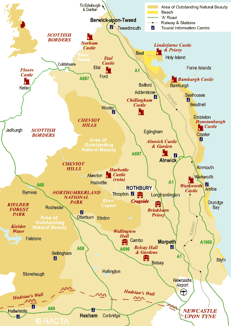
Tourist map of Northumberland.
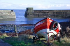
The county of Northumberland, in the North East of England, is one of the last great wildernesses of the United Kingdom.
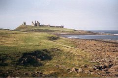
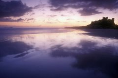
Once part of the Roman Empire and the scene of many wars between England and Scotland, Northumberland has a long and complicated history. This explains the many castles in Northumberland, including among the better-known those at Bamburgh, Dunstanburgh, Warkworth and Alnwick.
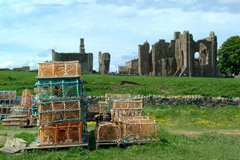
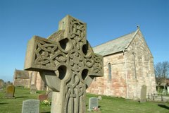
The region of present-day Northumberland once formed the core of the Anglian kingdom of Northumbria. Northumberland is called the "cradle of Christianity" in England, because it was on Lindisfarne, a tidal island north of Bamburgh, also called Holy Island, that Christianity flourished when monks from Iona were sent to convert the English. Lindisfarne was the home of the Lindisfarne Gospels and Saint Cuthbert, who is buried at Durham Cathedral.
Bamburgh is the historic capital of Northumberland, the "royal" castle from before the unification of England under one monarch. The capital of Northumberland now, however, may be thought to be the market town of Alnwick, mainly because the Duke of Northumberland has his home there; or may be thought of as Morpeth, since Northumberland County Council's offices are in that town.
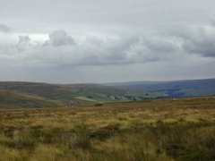
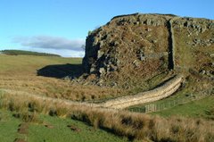
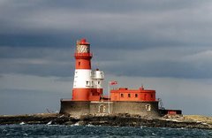
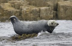
The physical geography of Northumberland is diverse. It is low and flat near the North Sea coast and increasingly mountainous toward the northwest. The Cheviot Hills, in the northwest of the county, consist mainly of resistant Devonian granite and andesite lava. A second area of igneous rock underlies Whin Sill (on which Hadrian's Wall runs), an intrusion of carboniferous Dolerite. Both ridges support a rather bare moorland landscape. Either side of Whin Sill the county lies on carboniferous limestone, giving some areas of karst landscape. Lying off the coast of Northumberland are the Farne Islands, another Dolerite outcrop, famous for their bird life.
There are coal fields in the southeast corner of the county, extending along the coastal region north of the river Tyne. The term sea coal likely originated from chunks of coal, found washed up on beaches, that wave action had broken from coastal outcroppings.
Being in the far north of England, above 55° latitude, and having many areas of high land, Northumberland is one of the coldest areas of the country. It has an average annual temperature of 7.1 to 9.3 °C, with the coldest temperatures inland. However, the county lies on the east coast, and has relatively low rainfall, between 466 and 1060 mm annually, mostly falling in the west on the high land. Between 1971 and 2000 the county averaged 1321 to 1390 hours of sunshine per year.
Approximately a quarter of the county is protected as the Northumberland National Park, an area of outstanding landscape that has largely been protected from development and agriculture. The park stretches south from the Scottish border and includes Hadrian's Wall. Most of the park is over 800 feet (240 metres) above sea level.
Each week I will describe where to go, what to do and beautiful places to see in My Northumberland.
Article adapted from the Wikipedia online encyclopedia.
Once part of the Roman Empire and the scene of many wars between England and Scotland, Northumberland has a long and complicated history. This explains the many castles in Northumberland, including among the better-known those at Bamburgh, Dunstanburgh, Warkworth and Alnwick.
The region of present-day Northumberland once formed the core of the Anglian kingdom of Northumbria. Northumberland is called the "cradle of Christianity" in England, because it was on Lindisfarne, a tidal island north of Bamburgh, also called Holy Island, that Christianity flourished when monks from Iona were sent to convert the English. Lindisfarne was the home of the Lindisfarne Gospels and Saint Cuthbert, who is buried at Durham Cathedral.
Bamburgh is the historic capital of Northumberland, the "royal" castle from before the unification of England under one monarch. The capital of Northumberland now, however, may be thought to be the market town of Alnwick, mainly because the Duke of Northumberland has his home there; or may be thought of as Morpeth, since Northumberland County Council's offices are in that town.
The physical geography of Northumberland is diverse. It is low and flat near the North Sea coast and increasingly mountainous toward the northwest. The Cheviot Hills, in the northwest of the county, consist mainly of resistant Devonian granite and andesite lava. A second area of igneous rock underlies Whin Sill (on which Hadrian's Wall runs), an intrusion of carboniferous Dolerite. Both ridges support a rather bare moorland landscape. Either side of Whin Sill the county lies on carboniferous limestone, giving some areas of karst landscape. Lying off the coast of Northumberland are the Farne Islands, another Dolerite outcrop, famous for their bird life.
There are coal fields in the southeast corner of the county, extending along the coastal region north of the river Tyne. The term sea coal likely originated from chunks of coal, found washed up on beaches, that wave action had broken from coastal outcroppings.
Being in the far north of England, above 55° latitude, and having many areas of high land, Northumberland is one of the coldest areas of the country. It has an average annual temperature of 7.1 to 9.3 °C, with the coldest temperatures inland. However, the county lies on the east coast, and has relatively low rainfall, between 466 and 1060 mm annually, mostly falling in the west on the high land. Between 1971 and 2000 the county averaged 1321 to 1390 hours of sunshine per year.
Approximately a quarter of the county is protected as the Northumberland National Park, an area of outstanding landscape that has largely been protected from development and agriculture. The park stretches south from the Scottish border and includes Hadrian's Wall. Most of the park is over 800 feet (240 metres) above sea level.
Each week I will describe where to go, what to do and beautiful places to see in My Northumberland.
Article adapted from the Wikipedia online encyclopedia.